Tuesday 20 October 2015

Trekking to Broghil over Darkot and Zindikhram passes(4575m).


This splendid trek gives a joy to those wish to walk over 4000 meters passes and enjoy of glaciers. It takes 5 to 22 days depends your time you wish to spend on trekking. This trek starts the wast Darkot village of North Pakistan and ends in three distinctive part of Chitral and Gilgit Baltistan/Northern Areas. As described above in the previous post trekking in Broghil and Korumbar Lake. This is the alternative trek towards Darkot Yasin from Ishkarwarz to the Southeast to the scenic and historical Darkot pass 4575 meters.


Ishkarwarz to Darkot Base Camp.
------------------------------------------------------
  Three to four hours. The path rises through undulating pastures to Chickar, the last settlement until Rawat, about 20 km away across the pass. Two and half hours easy walking along an excellent path on the side of the valley with first the river, then the glacier on your side takes you to the campsite surrounded by stone wall at 4100 meters and 100 metres above the glacier with views of white-tppoed peaks of Hindu Kush all around hopefully you will enjoy the natural beauty if you are lucky enough to have good weather.

  Darkot Base camp across the Pass to Rawat:
---------------------------------------------------------------------------
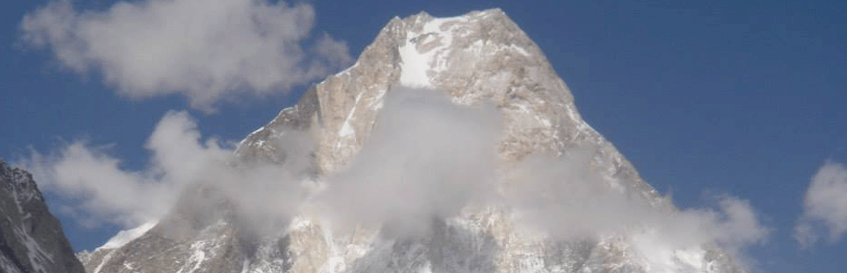
   Six to eight hours walk, for half an hour you will walk on the moraine of the glacier, then walk up to the middle of the wide flate Darkot glacier, crossing crevasses and streams of crystal clear ice water on the glacier for an easy two hours to reach the pass-- a flate circular pan cack at 4575 meters, that takes an about to half an hour to cross. In all directions, views of the granite peaks interspersed with glaciers. A glaciated ridge 200 metres high separated you from Zindikharam Pass ( will be mentioned in the next post.
  The descent to the Darkot side is steeper and need more careful while descending. It is wet and sleepry in the morning. After finishing the glaciers, you will be in  well-made path on the left and continue descending. You will reach a wonderful campsite of Rawat with clean spring water and grassy sof camping place the people Yasin Valley will welcome warmly and offer local dishes with salty tea an amazing experience of the people.
  Camp at 3700 meters and enjoy you afternoon with views of splendid valleys all around.

Rawat to Darkot:
---------------------------
  An easy walk of 2 hourcs on jeep roads to Darkot village giving a surprise the poeple your arrival in the Village and the villagers will happy to see you and welcome warmly. The Village is at 3300 meters.
  You can continue another 4 days trek from here to Ishkoman over Punji Pass or Attar Pass, if not you can drive to Gilgit or your next destination as  your program. I hope you will enjoy reading about this trek. If you wish to have an experience of the  trek feel free to contact.
 During the trek if you wish to ride on yalk or horse you can enjoy having this opportunity. I once used horse for a member who got altitude sickness on Kurombar Lake and came down to laskargaz by walking four hours.
 It was the time of dinner he was attacked by the sickness and we identified luckily and decided to move at the same time and we had horses  with us along with porters. It was great decision that i made with my leader and came down otherwise it could have been serious problem. By that time it was beginning of my guiding, still had common sense of making decisions on sudden time needs.

Tuesday 13 October 2015

Ishkoman to Darkote trek


 Ishkoman to Darkot over Attar pass(4762m).
-----------------------------------------------------------------------
  It is an easy and Interesting four to six days trek. You can start this trek from either sites from Ishkoman or Darkot. From Ishkoman a village  is called Ghotolti at the end of the jeep road  a beautiful village with seventy houses with views of snow-capped capped peaks of Karka which gives joy to the mountains and nature lovers.
  You drive only four hours from Gilgit acrossing beautiful villages of Ghizar district along the Ghizar River that flows from Hindukush mountains. It gets very high during the summer and unbelievable lowcin the winter season. It of the greatest rivers in Pakistan for the people who are interesting in rafting, that starts from the highest polo ground in the world Shandur on the altitude of 3400 meters.
The best season to go on this trek is mid-May to Mid-October.
 Day 1 Ghotolti to Mathan Tir: It is an interesting of 4 to 6 hours trek with the views of white-tppoed peaks of 5000 to 6000 metres. You cross a huge rockfall and continue to Hundis. At about 3000 metres, Hundis is the highest winter village, surrounded by fields of barley but to high for fruit trees. The views North up the Mathan Tir Valley showed jagged peaks. There is bridge which to the west from the Village which leads to another trek to Darkot over Punji Pass of 3 to 4 days.
 You will follow to the North along the river of Mathan Tir passing through many huts with local people who spend their summer wiht cattle welcoming you with cup of tea if  you get close to their huts which is an interesting culture of mountain communities of the Northern Pakistan and it is a great opportunity to discover their culture and living standards. Most of the people like to go on such treks that adds to their joys of holidays. You pass  undulating Day-ugh juniper scrub with occasional cedar, pine and Rowan trees and whildrose bushes. You pass a couple of settlements high above the path and it is gentle walk to reach Mathan Tir a beautiful summer village with green ground camping site at the side of Attar river with clear spring water to drink and cook at about 3200 metres.

Day-2: Margin Tir to Attar lake
--------------------------------------------------
  It is a three to four hours interesting day of the trek crossing through very beautiful summer villages along the Attar valley. There is path under the shade birch trees and views of surrounding snow-capped mountains of the 6000 to 6600 metres waiting for Summit.and names because the local are not aware about the joys of Climbing land mountains and still many of them without names. Some of the Italian were here since the year 2000, and enjoyed Climbing on these amazing mountains and gave them new names and discovered their local names, still many of them are un-named and waiting for Summit. After walking of 4 hours you will reach Attar lake the locals call Barri(means big) a beautiful campsite with clear water at about 3700 metres. There are some summer huts about 500 mteres to the lake. It is wonderful place to have a rest day her and Explore around. There some rock climbing part s very close to the camping site.and enjoy if you have some of your holidays to enjoy more most people like to do it.

Day-3:  Attar lake to Jutbar.
---------------------------------------
It is your third day of this trek a smooth walk of 3 to 4 hours walking along the Jutbar stream flows from ice and snow of the mountains with colourful flowers all along the way. You will reach to grassy campsite with wild onions. The views of the mountains back and ahead give immense happiness of your holidays. If you are interested to do afternoon Climbing, it spot that you can do it here on 5000 to 6000 peaks near your camp. This campsite is at the hight of about 4000 meters.

Day-4 Jutbar to Bohrek across the Attar pass:
----------------------------------------------------------------------------
  The climb to the northeast to the top is a steep-allow 4 to 5 hours to reach to the top. The last part to reach the pass is a gentle approach and you reach to 4350 meters and view to both sides is amazing with sane landscape and it is a bit confusing some for the people and ask about it. Sometimes there are snow in the early or late in the season on the pass I mean if you are there around the month of May and at the end of September. With in a one to one and half hour you reach to a beautiful campsite of the Yasin side with clear spring and views of narrow valleys down. Your porters celebrate the success by running down towards the campsite and welcome to the other side of the pass.you will camp here on about 3800 meters with clear spring water and soft grassy campsite.

Day-5 To Darkot of Yasin Valley:
------------------------------------------------------
  It is an easy walk of about 4 to 5 hours down wards and come acacros the summer huts of Bohrek, Momosil and Willing Harang with people of Darkot as the people like in the Ishkoman will be very happy to see you and welcome you with tea and local dishes made of milk. You must not deney the offers, that is unique culture of the mountain communities of North Pakistan. After walking 3 hour you will reach to the beautiful village of Darkot the last village of Yasin Valley. It has about 350 houses.
  There are two other treks from here, the famous strategic Darkot pass  5575 meters to Broghil of a four days to Chitral or  Ghambar pass 4600 m of two days easy trek to Thoi. I will write them in the next post with detail.

Saturday 3 October 2015

Trekking Areas

Wakhan Corridor trek in the Hindukush Range
It is one of the greatest treks in Pakistan in the Hindukush range that connects the Northern Areas to Khyber Pokhtun Khawn province. It is wonder ful trek of two weeks along the Wakhan Corridor. This trek begins from the Village Yarkun Lasht the remotest village of Chitral district Of Khyber Pokhtun Khawn and ends in Chupursen in upper Hunza Gilgit Baltistan province.
  The trek starts from the Village where the jeep road ends from Chitral city where it takes 6 to 7 hours along the beautiful villages of  Boni, Mastuj, Brep and many other small villages. Half of the road is matalled and half is the bumpy rough dusty road with superb views of snow-capped mountains all arrond that adds to the joys of your holidays.
  Trek from Lasht to Khishmanja: 
It is an easy 4 to 5 hours walk along the Yarkhun river with clear path along the fields of barley and lush green areas. The people of the region are always friendly and your porters always ready to help you along the way where there is small stream to  cross too. You will enjoy this beautiful walk of four to five hour and reach to camping place call Khishmanja a place under shade of trees with clear stream a small village where 7 to 10 house holds are living. The people are simple speaking Wakhi language claim to be migrated from Wakhan welcome you to go the  camp warmly. They will be very happy of your visit to their small homes and offer you tea or some local dishes which is unique culture of the mountain communities of Pakistan. 
Khishmanja to Chickar/ Ishkarwarz:
  This is the second day of your trek you walk 6 to 7 hours along the Yarkhun River, with spectacular views of the Hindu Kush mountains most of them are below 6000 meters and below but they higher and beautiful. As I mentioned in the previous posts and that many of th m are still unclimed and named. Your way to Chickar is smooth and gentle and the altitude gets higher day by day. You will come me across very few small villages as the population is a little because of its harsh climate and being a backward part of Pakistan. You will reach to Chickar a beautiful campsite opposite Darkote pass (4550 m) will be given details in the next posts. Chickar is village at the altitude of 3400 meters with grassy carpeted campsite, my clients always say a luxurious campsite with natural unbelievable scenery. The people here are in a harsh co dition very fields of barley are there and most of the male used to outside of the Village to work such as places Gilgit and Chitral doing Labor jobs to survive.


  1. To the southeast the trek leads to the scenic Darkot pass(4575 m)I I will explain about this historical and interest pass in the next posts.

It will be Interesting day if you stay one rest day here and make a day hike of 6 to 8 hours to the Broghil Pass (3708 m) to have a look to Wakhan side, it is closed to cross to the other side.
Chickar to Lashkar gaz: or Dakot pass BC
  One of the most interesting day of this trek four to five hour mooth and easy walk along the Broghil River flows down from  Chaintir gand Zindikharam glaciers. As the previous day there very small villages along the way and see very fee people children and women mostly as I told earlier the men go to work outside of the Village. You will reach to Lashkar gaz a beautiful plain grassy flate place with about house holds. You will camp here and enjoy the  views of beautiful heart touching scenery at the altitude of 3600 meters.there are about eight houses along the leader of Broghil, the Mayyor whose family members living here. The villagers are very friendly offer you the tea as the villages of Hindu kush.
  Lashkargaz  to Korumbar Lake :
 This day is very interesting of four to five hours walk with the spectacular views the snow-capped peaks ahead and lush green meadows in the surrounding valleys. You come across the fields barley with permanent  settlements. The walk is smooth all the way and every few minutes you come to huge, lone huts or cluster of huts surrounded by fields of barley an spinach. On this day you will have a great view of Darwaza Pass (3880 meters) entry to the Wakhan Corridor and further hour bring you to the village of Lashkar Gaz which consist of about fifteen houses scattered over the plain with beautiful small ponds of spring water in the surrounding area.The villagers will welcome you on your arrival here and camp here. There is great walk up to the village for clear views ahead and back. I love the campsite at all you will enjoy the night too.
 Lashkar Gaz to Laly Ribbat: This is three to four hours easy walk of  the trek with great views of Zidhighram Pass and the glacier to the south, you come across the summer huts of the people from Broghil during the month of July and August people stay here with herds of goats and sheep. The path is smooth all the way and interesting with views of Darkot Pass to the south and Chiantir Glacier to the east and reach to the campsite of Laly Ribbat some summer houses with stone huts. People here are friendly as the previous villages gather around you the whole day. They have nothing to do there only looking after the animals the whole day from the houses. You will enjoy the night here 3600 meter. If you are not afraid of acclimatization you continue to the Korumbabr Lake another two to three hours walk.
Laly Ribbat to Korumbar Lake: Two to three hours very interesting smooth walk towards the Korumbar Pass and Lake. The herds of yaks, horses, goats and sheep are there all around.( If you wish to ride a horse or yak you can  hire here to enjoy riding). As the previous day there are stunning views of white peaks 5000 to 6000 meters, and green meadows add to the joy of your trip. After three hours walk you will be at the Korumbar Pass  at 4,200 meters, is a flat and marshy, with russet-colored pools draining into a small lake on Chitral side and the large Korumbar Lake on the Ishkoman side. there are couple of stone shelter for you porters to stay and flat grassy and softy camp site to stay here it is worth to stay more days on this spot if have enough time. A glaciated ridge of mountains forms a 5,700 m well hemming in the pass on the south, with shimmering ice tumbling in step down towards the pass.  The northern wall, its bare grey green slopes warmed by the sun, rises to the same height. Sometimes people stay more days  to enjoy climbing the surrounding mountains which no need permit to climb below 6,000 meter.
Korumbar Lake to Shuinji: